Description
One of the most useful data products generated by the Long Island Sound Seafloor Habitat Mapping Initiative is the Integrated Habitat Map, a comprehensive spatial tool to assist with management decisions. These products are created by combining all of the mapping elements into one map using a geographic information system (GIS). The development of the map starts with the major patch types identified by the acoustic backscatter mosaic. The derived acoustic product, the Topographic Roughness Index (TRI) further refines these classes. The results of the sediment data analyses that validated the bottom composition (grain size) are then overlain. The distribution of the dominant infaunal and epifaunal taxa are included for each patch type. Finally, the physical bottom stress environment that these organisms encounter is included. All of the factors are considered in defining the seafloor habitat of each of the patch types.
To learn more about integrated habitat maps you can visit this Story Map: A Habitat Map for Long Island Sound
Or access this publication: Zajac, R.N., Stefaniak, L.M., Babb, I.B., Conroy, C.W., Penna, S., Chadi, D., Auster, P.J. (2020). An integrated seafloor habitat map to inform marine spatial planning and management: a case study from Long Island Sound (Northwest Atlantic). In: Seafloor Geomorphology as Benthic Habitat: GeoHab Atlas of Seafloor Geomorphic Features and Benthic Habitats. 2020. Harris, P. T. and Baker, E. Eds. Elsevier Inc. 1078 pp. DOI: https://doi.org/10.1016/B978-0-12-814960-7.00010-5
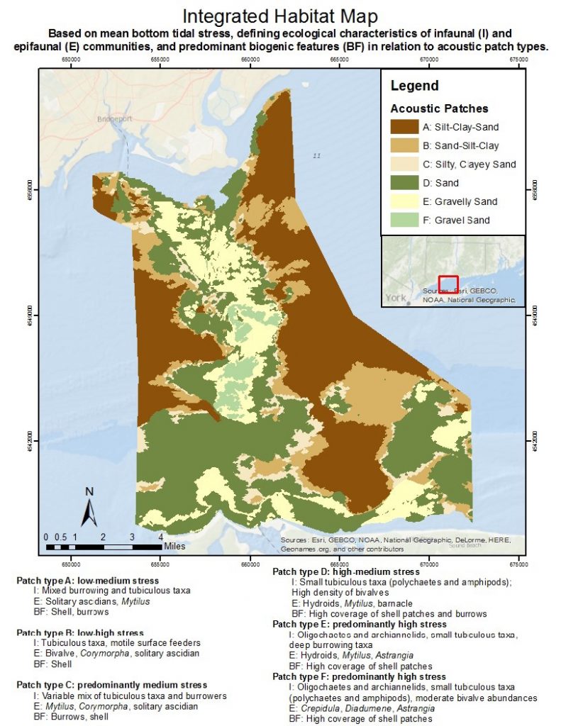
Phase I – Central Long Island Sound Habitat Map
An integrated habitat map links acoustic patch types to mean bottom tidal stress and the defining ecological characteristics of infauna, epifauna, and biogenic features. Notable is the faunal response to the general gradient in grain size from acoustic patch types A to F (i.e., fine to coarse) along with the concomitant gradient of increasing tidal stress. The trend here is between these characteristics of the physical environment, the shifts in infaunal taxa, the shift from short-lived to long-lived fragile epifaunal species, and the shift from burrowed sediments to high coverage patches of biogenic shell.
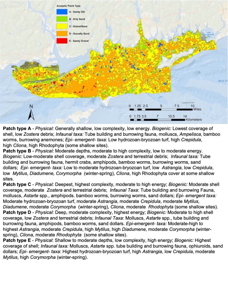
Phase II – Eastern Long Island Sound Habitat Map
This integrated habitat map links acoustic patch types to generalized physical and the defining ecological characteristics of biogenic features, infauna, and epi- and emergent fauna. It is notable that the faunal response to the general gradient in grain size from patch types A to E (i.e., finer to coarser sediments) along with the concomitant physical gradient. The ecological pattern in this area comports with the similarity of sediment composition (a gradient of sand-gravel) such that patterns of diversity and dominance shift across patches but are drawn from a similar species pool. Depth, tidal stress, and related measures are correlated with such changes, but species life-histories will be important for predicting the effects of ecological disturbance to human-caused impacts and patterns of resilience (e.g., acute versus chronic stresses and small versus large spatial scales).