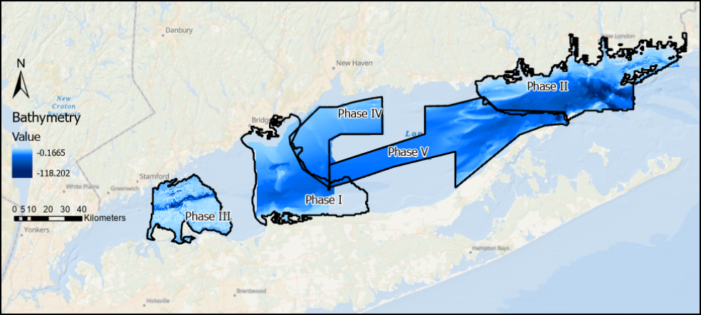
The Long Island Sound Seafloor Habitat Mapping Initiative is a federal, state and academic partnership that is applying some of the most advanced technologies available today to develop data and map products to guide decisions to better manage the Sound. Funded by the Long Island Sound Cable Fund and administered by the Long Island Sound Study the initiative has completed two phases (Phase 1 – Central and Phase 2 – Eastern Sound) and is in the process of completing a third (Phase III – West Central) and fourth (Phase IV – East Central) phases. A fifth area (Phase V) has been mapped acoustically and will be characterized in 2026.
These are areas selected by managers and scientists as high priority areas for habitat mapping. The comprehensive information needed to manage Long Island Sound and its resources is being gathered at a range of scales as the Sound is diverse in its topography, which in turn supports a diversity of life and natural resources. Scientists are using a variety of technologies that provide data on a range of scales, from big picture acoustic maps providing an underwater satellite perspective of the features of the underwater landscape to the fine scale distribution of organisms living on and in the features of the seafloor.
This web site provides information on the background and motivation for the mapping initiative, updates on the field activities conducted to date, interpretive story maps describing some of the results to date and multimedia links to images and video of the beauty and complexity of Sound.